
Taylors ZIP Code Directory Coverage
The verified postal label in the Taylors ZIP code directory is 29687. Greenville County GIS documentation includes the Taylors city-and-ZIP pairing, and County election-location material also uses Taylors, South Carolina 29687. That is the one code the research confirms for the community. It is a mail-routing label, not a Taylors government boundary. The sources reviewed do not establish a second ZIP serving the Taylors CDP, a PO-box-only Taylors ZIP, a unique institution ZIP, or a dated ZIP realignment.
| ZIP | Supported Taylors geography | Postal label | Record-use note |
|---|---|---|---|
| 29687 | Taylors-labeled addresses in Greenville County GIS and County election-location material | Taylors, subject to live USPS verification | Primary verified Taylors ZIP; not a governmental, parcel, or custodian boundary |
Use USPS City and State mode when the question is which codes are currently deliverable for a postal city. Run the full-address mode again for a particular address because routes can change. An address near the edge of the Taylors CDP may use a Greenville or Greer postal label while remaining under Greenville County's record custodians. The exact parcel, rather than the postal name, controls the property trail.
Verify a Taylors ZIP Code With USPS
The USPS ZIP Code Lookup is the live postal verifier for a Taylors address. It offers three different routes. ZIP Code by Address requires Street Address plus City/State or Street Address plus ZIP, with optional Company and Apt/Suite/Other fields. ZIP Code by City and State returns the codes for a named postal city. Cities by ZIP Code starts with the code. USPS warns that a result does not confirm that a person or business is at an address.
| USPS mode or field | What to enter | Useful result | Boundary |
|---|---|---|---|
| ZIP Code by Address | Street Address plus City/State or ZIP; optional unit details | Postal routing check for one complete Taylors address | Does not establish a person, owner, or physical parcel |
| ZIP Code by City and State | Postal city and state | Current codes USPS associates with that postal city | Not a CDP or municipal-boundary test |
| Cities by ZIP Code | ZIP Code | Postal city names associated with the entered code | Not an address or residency confirmation |
After USPS returns a code, copy the result into research notes beside the address and date checked. Then move to the parcel tools. This is the right order because a postal answer can be current and still say nothing about the land description, the responsible record office, or the people associated with that address.
Taylors ZIP Code Directory Parcel Route
A Taylors ZIP code directory does not unlock a county-wide parcel list. The public Real Property form has Tax Year, Name, Street, Map No., Subdivision, and Sales Sheet fields. It does not display a ZIP field. Greenville County GIS can show an owner mailing city, state, and ZIP on a Property Report, yet the public interface was not verified as a ZIP-wide parcel filter. The Register of Deeds searches names, instrument number, book/page, and legal description, not ZIP codes.
- Confirm a full Taylors address with USPS, rather than relying on a postal-city assumption.
- Enter the same address into Greenville County Maps and save the selected parcel's PIN and outline.
- Open the Property Report and compare Location with the owner mailing fields. Keep the two labels separate.
- Use the PIN, deed book/page, plat reference, or legal description in ROD Search Records when the question becomes a land-record question.
- Use the exact street or PIN in Real Property Search for the current assessment record. For a full street-by-street parcel method, use the Taylors street directory.
Greenville County's property-detail example is the source captured for the Taylors ZIP code directory fields that distinguish location from correspondence information.
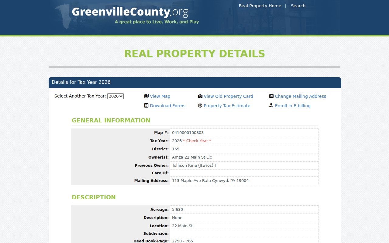
The example demonstrates why a mailing ZIP belongs to the owner-information side of a property record and should not be substituted for the parcel's physical Location.
Taylors ZIP Code and Parcel Labels
Three labels should travel together but never be collapsed into one. The situs or Location is the physical Taylors street location on the property report. The owner mailing address is correspondence data and may have a different city or ZIP. The legal description or PIN is the stable bridge to a lot, block, subdivision, metes-and-bounds description, deed book/page, or plat book/page. This distinction protects a ZIP code directory search from making a postal fact do the work of a title or map record.
Greenville County Maps can find addresses, roads, and tax parcels, then open a Property Report with deed and plat references. County data also includes road centerlines, municipal boundaries, polling locations, and address-point attributes. Its historical imagery can help assess a physical change across years. It does not create a ZIP-based people list, and its parcel report is not a substitute for a survey, appraisal, title examination, or official zoning determination.
Note: Record the postal code, map number, Location, and legal reference separately before comparing an old Taylors address.
Taylors ZIP Code Is Not a City Line
Taylors is a Census-designated place, not an incorporated municipality. Its 2020 Census population was 23,222 across 10.56 square land miles, but that statistical geography does not turn 29687 into a municipal boundary. ZIP Codes are USPS delivery routes made from streets or delivery points. Census ZIP Code Tabulation Areas are generalized approximations used for statistics, not official delivery boundaries. A postal city name can extend beyond a legal or Census boundary.
Postal boundary check. A Taylors ZIP code can confirm mail routing for an exact address. It cannot prove a physical parcel, a county-record custodian, ownership, or who is connected with that address.
This is the central Taylors ZIP code directory comparison. The CDP, postal city, parcel, special district, and county planning area are overlapping geography layers with different purposes. Greenville County remains the principal address, deed, map, permit, and court record setting because Taylors is unincorporated. A postal result should never redirect an address question away from the county systems that hold its records.
Taylors ZIP Code Directory Map Checks
For a border-address question, use a short sequence: verify the mail route with USPS, find the physical address in County Maps, save the PIN and parcel outline, read Location apart from owner correspondence, and follow the deed or plat references if the record question continues. That approach is stronger than relying on a preferred city label. It also keeps the record custodian stable when an address sits near Greenville or Greer postal geography.
Greenville County GIS's FAQ is the source captured for the Taylors ZIP code directory discussion of map-data limitations and update context.
County map data is helpful for locating a parcel, but the source's cautions make an official record check important when a boundary or legal description matters.
Greenville County Maps has a newer application in transition, while the County's documented parcel, ownership, legal-reference, and road-centerline information updates daily. Timely mapping makes it a strong place check. It does not give the map final legal force.
Taylors ZIP Code Address Authority
The Greenville County Office of E-911 assigns property addresses. It participates with Planning and Public Works in street-name approval, does not allow duplicate street names, and approves private roads. A PD on a sign means private drive. Those details matter before a Taylors ZIP code directory search is joined to a street record. Check the number, suffix, direction, and private-drive status instead of guessing from a shortened address.
Greenville County E-911 property-address information is the source captured for this Taylors address-assignment route.
The E-911 route is the appropriate contact for a property-address issue, while the postal lookup remains the mail-routing check.
For a possible changed road name, County Planning requires a petition by every frontage owner, review by the Subdivision Advisory Committee and Planning Commission, public Commission action, and an approved certificate recorded at the ROD. The County lists a $150 replacement-sign fee. No research source verifies a Taylors-wide renumbering, street grid, ZIP split, or realignment, so an individual change should be checked through E-911, Planning, ROD, historic plats, and maps.
Taylors ZIP Code Directory Limits
The ZIP code directory is a postal reference, not a resident list. USPS says its result does not confirm a person or business at an address. The assessor's public search is street and PIN first, the ROD is legal-description and instrument first, and My SC Votes is a credentialed individual service with no ZIP field or browse mode. The county Code Compliance form is address-specific, and eTrakit access is account-oriented. None of those channels supports a legitimate ZIP-wide roster.
- ZIP Code
- A USPS delivery-routing code, not a local-government boundary.
- ZIP+4
- An added four-digit delivery segment used with a base ZIP for more precise mail routing.
- PO-box ZIP
- A code assigned to post-office boxes rather than ordinary delivery addresses. No Taylors-only example was verified in the research.
- Unique ZIP
- A code for one organization or destination. No Taylors example was verified in the research.
- Carrier route
- A postal delivery grouping. It is not a substitute for a parcel boundary or property record.
When an online result is not enough, use the documented fallback for the source involved. USPS handles delivery verification. County Maps and Real Property handle parcel context. ROD provides online, counter, phone, and mail copy routes for land instruments. E-911 handles address-assignment questions. A lawful personal research purpose and careful record-by-record verification remain essential.